The process, in a nutshell, is quite simple. GPS receiver in your mobile phone gets radio signals from GPS satellites in the space, and according to their position and signals traveling time, calculates its position and then shows it on a map stored in the mobile phone. Simple as that. No, your phone isn't sending anything back to GPS, and that's why you can use the navigation offline. Of course, when you are online, your mobile phone (or another device you're using) can download an updated map, get real-time traffic information, and send its position to third parties like your map provider or your mobile network provider.
Ok, got it, but what is GPS? Are there similar systems?
GPS or NAVSTAR Global Positioning System is made of 31 active satellites, 9 in reserve, and 2 in testing phase. Satellites are constantly spinning around Earth, and each spot on Earth is covered by a signal from at least 4 of them. It's interesting to know that actually 30 satellites have been retired, and 2 were lost at launch. Every satellite needs to be replaced with a new one after a certain period. The United States Department of Defense developed GPS during the 1970s for military use. From 1983 it was partly publicly available, and from 2000 it's available for everyone who has GPS receiver without limitations. It's not the only system of that kind. There is also BeiDou-3 system made by China, Galileo system made by European Union and Globalnaya Navigatsionnaya Sputnikovaya Sistema, or GLONASS made by Russia. All of these are examples of GNSS – Global navigation system – a system that sends signals from space about its location and time of broadcasting and covers all places on Earth.
So, how is your position calculated exactly?
Let's describe how GPS works in more detail. GPS satellite broadcasts radio signal with information about its position and time of sending a signal. To define its position, GPS receiver needs signals from at least 3 GPS satellites. More satellites, better accuracy. That's why each spot on our planet is covered with at least 4 satellites. After receiving a radio signal, a receiver calculates the time taken for a radio signal from a satellite to reach a receiver. It's done by comparing the time of transmission encoded in satellite's signal with the time of arrival of the signal according to the receiver's device clock. Since the signal travels approximately by the speed of light, the distance between a satellite and a receiver can be accurately calculated with some adjustment. Combined with the satellite position data encoded in each satellite's signal, this information allows a receiver to calculate its longitude, latitude, and altitude. GPS receiver calculates its position through the process of trilateration which goes like this:
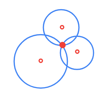
If you know you are at a distance a from satellite A, you can think of yourself as being on the surface of an imaginary sphere of radius a, with its center at satellite A's coordinates. Now imagine yourself being at distance b from satellite B by the same process. You can draw a sphere with radius b. The two spheres will overlap and intersect in a circle. To get a more accurate position, you need a third satellite. Let's call the third satellite C with a radius c. The overlap between all three spheres, now occurs at just two points, one of which is on the surface of Earth and represents your location. Because of this, three satellites are generally sufficient to establish latitude and longitude of a GPS receiver. A fourth satellite, however, can be used to provide both higher accuracy and altitude information.